Description
Geologists research the materials that form the earth. Their observations depend on the purpose of the research. Depending on their specialisation, geologists study how the Earth has been shaped over time, its geological layers, the quality of minerals for mining purposes, earthquakes and volcanic activity for private services, and similar phenomena.
Duties
Geologists typically do the following:
- Conduct field studies to collect rock, mineral, and soil samples, and observe geological formations and processes.
- Analyze samples using various techniques, including microscopy, spectroscopy, and chemical analysis, to determine their composition and properties.
- Create geological maps and cross-sections to represent the distribution of different rocks and geological features.
- Interpret geological data to understand the history and structure of the Earth’s crust and predict future geological events.
- Conduct research to advance the understanding of geological processes and contribute to scientific knowledge.
- Assess potential sites for natural resource extraction, such as oil, gas, minerals, and groundwater.
- Evaluate the impact of human activities on geological environments and provide recommendations for sustainable practices.
- Analyze geological hazards, such as earthquakes, landslides, and volcanic eruptions, and develop risk mitigation strategies.
- Prepare detailed reports, scientific papers, and presentations to communicate findings to clients, stakeholders, and the scientific community.
- Educate the public and stakeholders about geological issues and the importance of geology in everyday life.
Sign in to contribute to the Duties section
Other titles
The following job titles also refer to geologist:
geologists
paedologist
geology studies research analyst
geology analyst
geology research analyst
geologist prospector
geology scientist
petroleum geologist
geology studies scientist
site geologist
geology science researcher
glaciologist
structural geologist
geology researcher
geology studies analyst
geology studies research scientist
geology research scientist
chief geologist
bedrock geologist
geoscience consultant
geology studies researcher
geology scholar
geothermal scientist
volcanologist
geologist engineer
consulting geologist
field geologist
coal geologist
sedimentologist
geology studies scholar
quaternary geologist
Working conditions
Geologists work in a variety of environments, including outdoor field sites, laboratories, and offices. Fieldwork can involve travel to remote and rugged locations, often requiring physical stamina and endurance. Conditions can be challenging, with exposure to adverse weather and difficult terrain. Laboratory work involves the use of specialized equipment and software for analyzing geological samples and data. Office work includes data analysis, report writing, and collaboration with other scientists and professionals.
Geologists often work in multidisciplinary teams and may need to communicate their findings to non-specialists, such as government officials, community groups, and industry stakeholders.
Sign in to contribute to the Working conditions section
Minimum qualifications
A bachelor’s degree in geology, earth sciences, or a related field is typically required, though advanced positions often require a master’s degree or Ph.D. Specialized courses in mineralogy, petrology, sedimentology, paleontology, and structural geology are essential.
Practical experience through internships, field camps, and research projects is highly beneficial. Proficiency in geological mapping, data analysis, and the use of geographic information systems (GIS) and other specialized software is crucial. Continuous professional development through workshops, conferences, and membership in geological societies helps geologists stay current with advances in the field. Strong analytical, observational, and communication skills are vital for success as a geologist.
Sign in to contribute to the Minimum qualifications section
Salary
Sign in to contribute to the Salary section
ISCO skill level
ISCO skill level is defined as a function of the complexity and range of tasks and duties to be performed in an occupation. It is measured on a scale from 1 to 4, with 1 the lowest level and 4 the highest, by considering:
- the nature of the work performed in an occupation in relation to the characteristic tasks and duties
- the level of formal education required for competent performance of the tasks and duties involved and
- the amount of informal on-the-job training and/or previous experience in a related occupation required for competent performance of these tasks and duties.
Geologist is a Skill level 4 occupation.
Potential next steps
How to get here
Occupations that commonly lead to this role, based on skill overlap and career proximity.
General track
These occupations share a similar skill set and naturally lead to this role.
- seismologistMatch: 91%
- astronomerMatch: 82%
- meteorologistMatch: 77%
- hydrologistMatch: 74%
- cosmetic chemistMatch: 67%
Expert track
These occupations build toward the deeper specialisation required for this role.
- oceanographerMatch: 86%
- palaeontologistMatch: 89%
- analytical chemistMatch: 72%
- mineralogistMatch: 86%
Essential knowledge and skills
Essential knowledge
This knowledge should be acquired through learning to fulfill the role of geologist.
- Cartography: The study of interpreting the elements depicted in maps, the measures and technical specifications.
- Mathematics: Mathematics is the study of topics such as quantity, structure, space, and change. It involves the identification of patterns and formulating new conjectures based on them. Mathematicians strive to prove the truth or falsity of these conjectures. There are many fields of mathematics, some of which are widely used for practical applications.
- Geological time scale: System of chronological measurement dividing geologic history into several temporal divisions and subdivisions that take ancient life, geography, and climates into account.
- Statistics: The study of statistical theory, methods and practices such as collection, organisation, analysis, interpretation and presentation of data. It deals with all aspects of data including the planning of data collection in terms of the design of surveys and experiments in order to forecast and plan work-related activities.
- Geology: Solid earth, rock types, structures and the processes by which they are altered.
- Scientific modelling: Scientific activity consisting in selecting the relevant aspects of a situation and aiming to represent physical processes, empirical objects and phenomena to allow a better understanding, visualisation or quantification, and to enable simulation that shows how this particular subject would behave under given circumstances.
- Scientific research methodology: The theoretical methodology used in scientific research involving doing background research, constructing an hypothesis, testing it, analysing data and concluding the results.
Essential skills and competences
These skills are necessary for the role of geologist.
- Perform laboratory tests: Carry out tests in a laboratory to produce reliable and precise data to support scientific research and product testing.
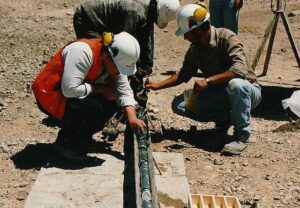
- Collect geological data: Participate in the collection of geological data such as core logging, geological mapping, geochemical and geophysical surveying, digital data capture, etc.
- Execute analytical mathematical calculations: Apply mathematical methods and make use of calculation technologies in order to perform analyses and devise solutions to specific problems.
- Record test data: Record data that has been identified specifically during preceding tests in order to verify that outputs of the test produce specific results or to review the reaction of the subject under exceptional or unusual input.
- Apply statistical analysis techniques: Use models (descriptive or inferential statistics) and techniques (data mining or machine learning) for statistical analysis and ICT tools to analyse data, uncover correlations and forecast trends.
- Perform scientific research: Gain, correct or improve knowledge about phenomena by using scientific methods and techniques, based on empirical or measurable observations.
- Apply safety procedures in laboratory: Make sure that laboratory equipment is used in a safe manner and the handling of samples and specimens is correct. Work to ensure the validity of results obtained in research.
- Apply scientific methods: Apply scientific methods and techniques to investigate phenomena, by acquiring new knowledge or correcting and integrating previous knowledge.
- Calibrate laboratory equipment: Calibrate laboratory equipment by comparing two measurements: one of known magnitude or correctness, made with a trusted device, and a second measurement from another piece of laboratory equipment. Make the measurements as similar as possible.
- Carry out geological explorations: Perform exploration activities for mines and fields to analyse the area’s properties and find ores.
- Conduct soil sample tests: Analyse and test soil samples; determine gas chromatography and gather relevant isotope and carbon information; determine viscosity.
- Write scientific papers: Present the hypothesis, findings, and conclusions of your scientific research in your field of expertise in a professional publication.
- Operate scientific measuring equipment: Operate devices, machinery, and equipment designed for scientific measurement. Scientific equipment consists of specialised measuring instruments refined to facilitate the acquisition of data.
Optional knowledge and skills
Optional knowledge
This knowledge is sometimes, but not always, required for the role of geologist. However, mastering this knowledge allows you to have more opportunities for career development.
- Geological mapping: The technique used to create maps that clearly illustrate the geological features and rock layers of an area that may be useful for mining projects and geological explorations.
- Impact of geological factors on mining operations: Be aware of the impact of geological factors, such as faults and rock movements, on mining operations.
- Geographic information systems: The tools involved in geographical mapping and positioning, such as GPS (global positioning systems), GIS (geographical information systems), and RS (remote sensing).
- Petrology: The scientific field of geology that studies the composition, structure, texture, other characteristics, and regional gradations of rocks.
- Environmental legislation: The environmental policies and legislation applicable in a certain domain.
- Geochemistry: The scientific discipline that studies the presence and distribution of chemical elements in the geological systems of Earth.
- Sedimentology: The study of sediments, namely sand, clay, and silt, and the natural processes undergone in their formation.
- Geophysics: The scientific field that deals with the physical processes and properties of the spatial environment surrounding Earth. Geophysics also deals with the quantitative analysis of phenomena such as magnetic fields, the internal structure of Earth, and its hydrological cycle.
- Soil science: The field of science that studies soil as a natural resource, its characteristics, formation, and classification. It also examines the physical, biological, and chemical potential of soil.
- Geochronology: The branch of geology and scientific field specialised in dating the age of rocks, rock formations, and sediments in order to determine geological events and map the chronology of Earth.
- Logging: The process of felling, cutting trees and transforming them into timber, including mechanical felling and processing.
Optional skills and competences
These skills and competences are sometimes, but not always, required for the role of geologist. However, mastering these skills and competences allows you to have more opportunities for career development.
- Examine geochemical samples: Analyse laboratory samples using equipment such as spectrometers, gas chromatographs, microscopes, microprobes and carbon analysers. Determine the age and characteristics of environmental samples such as minerals, rocks or soil.
- Conduct sediment control: Manage sediment control processes and projects. Plan sediment control actions to prevent eroded soil from polluting nearby waterways.
- Write research proposals: Synthetise and write proposals aiming to solve research problems. Draft the proposal baseline and objectives, the estimated budget, risks and impact. Document the advances and new developments on the relevant subject and field of study.
- Prepare surveying report: Write a survey report containing information on property boundaries, the height and depth of the terrain, etc..
- Conduct land surveys: Conduct surveys to determine the location and features of natural and man-made structures, on surface level as well as underground and underwater. Operate electronic distance-measuring equipment and digital measuring instruments.
- Advise on building matters: Provide advice on building matters to the various parties involved in construction projects. Bring to their awareness important building considerations and consult on construction budgets.
- Use geographic information systems: Work with computer data systems such as Geographic Information Systems (GIS).
- Collect samples for analysis: Collect samples of materials or products for laboratory analysis.
- Develop geological databases: Develop geological databases in order to acquire and organise information.
- Study aerial photos: Use aerial photos to study phenomena on Earth’s surface.
- Develop scientific theories: Formulate scientific theories based on empirical observations, gathered data and theories of other scientists.
- Apply digital mapping: Make maps by formatting compiled data into a virtual image that gives a precise representation of a specific area.
- Develop scientific research protocols: Develop and record the procedural method used for a specific scientific experiment in order to enable its replication.
- Interpret geophysical data: Interpret data of a geophysical nature: Earth’s shape, its gravitational and magnetic fields, its structure and composition, and geophysical dynamics and their surface expression in plate tectonics.
- Conduct field work: Conduct field work or research which is the collection of information outside of a laboratory or workplace setting. Visit places in order to collect specific information about the field.
- Provide technical expertise: Provide expert knowledge in a particular field, especially concerning mechanical or scientific subjects, to decision makers, engineers, technical staff or journalists.
- Provide information on geological characteristics: Provide information on geological structures, host rock quality, groundwater implications and details on the mineralogical and textural composition of ores to enable mining and processing to be planned efficiently. The geological model is used to design the mine workings for minimum dilution and maximum ore extraction.
- Assess environmental impact: Monitor environmental impacts and carry out assessments in order to identify and to reduce the organisation’s environmental risks while taking costs into account.
- Advise on geology for mineral extraction: Provide advice of the impact of geological factors on the development of mineral production. Take into account factors such as cost, safety, and characteristics of deposits.
- Design scientific equipment: Design new equipment or adapt existing equipment to aid scientists in gathering and analysing data and samples.
- Process data: Enter information into a data storage and data retrieval system via processes such as scanning, manual keying or electronic data transfer in order to process large amounts of data.
- Investigate soil stability: Collect soil samples from the railway site, using bores and test pits in order to determine ground stress capability and stability.
- Prepare geological map sections: Prepare geological sections, a vertical view of the local geology.
Skills group distribution
ISCO group and title
2114 – Geologists and geophysicists
References
- Geologist – ESCO
- Geologist in Canada | Job description – Job Bank
- Geologist Job Description – Indeed.com
- Featured image: By No machine-readable author provided. Geoz assumed (based on copyright claims). – No machine-readable source provided. Own work assumed (based on copyright claims)., Public Domain